
Superfortress RB-29A 44-61999 ‘Over-Exposed!’ (the ‘Bleaklow Bomber’)

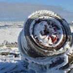

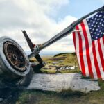


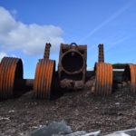

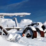

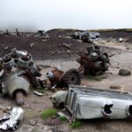

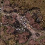


RB29 Superfortress air crash site at Higher Shelf Stones on Bleaklow.
History (scroll down for notes on visiting the crash site and moving on to other crash sites on Bleaklow)
The Superfortress took off on the morning of 3 November 1948, at around 10.15 from Scampton, Lincolnshire for Burtonwood USAF base, near Warrington, England. It was a routine flight with 2 other aircraft, the RB29 carrying USAF wages among other things. The crew were due to return to the States a few days later.
When ‘Over Exposed!’ failed to arrive at Burtonwood, an air search was initiated and that afternoon the burning wreck was spotted high on the moors near Higher Shelf Stones. By chance members of the Harpur Hill RAF Mountain Rescue Unit were just finishing an exercise two and a half miles away, so they quickly made their way to the scene of the crash but there was clearly nothing that could have been done for any of the crew.
All 13 men on board were killed instantly when the aircraft flew into the moor. It is not known why Captain Tanner did not fly at a height sufficient to clear the high ground.
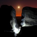
For more, please see the account of a member of the recovery party which arrived on site the day after (photo above, top left or link here).
‘Over Exposed!’ was a photo reconnaissance aircraft – hence the name – and had photographed some of the nuclear bomb tests at Bikini Atoll in the Pacific Ocean and had taken part in the Berlin airlift. I have been told the name was given to the aircraft after getting too close to the flash during nuclear bomb Test Able in July 1946.
CREW
Pilot, Captain Landon P. Tanner
Co-pilot, Captain Harry Stroud
Engineer, Technical Sergeant Ralph Fields
Navigator, Sergeant Charles Wilbanks
Radio Operator, Staff Sergeant Gene A. Gartner
Radar Operator, Staff Sergeant David D. Moore
CAMERA CREW
Technical Sergeant Saul R. Banks
Sergeant Donald R. Abrogast
Sergeant Robert I. Doyle
Private First Class William M. Burrows.
Corporal M. Franssen
Corporal George Ingram
Acting as photographic adviser was Captain Howard Keel of the 4201st Motion Picture Unit.
Photoset of RAF Harper Hill Mountain Rescue Team which includes photos taken during the recovery operation.
Visiting the crash site from the top of the Snake Pass (car parking)
Most recent update 21 January 2023
The crash site on Google Maps
maps.google.co.uk/maps?hl=en&ll=53.45054,-1.864591&am…
View on Bing maps using Ordnance Survey mapping. Can’t be viewed on a phone, unfortunately.
Approximate post code for the lay-by is S33 0AB
From October 2020, there was a bus route over the Snake Pass with bus stops at the top of the pass but this service stopped in January 2022. As of July 2022 the bus stops are still there but there is no bus service.
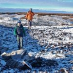
My preference would be to visit the crash site from the trig point at Higher Shelf Stones but the directions provided below are for the quickest routes to the site. It is about 45 – 60 minutes walk to the crash site from the lay-by (car parking and bus stops) at the summit of Snake Pass.
Warnings and disclaimer
If you are planning to visit the crash site, the usual warnings about having the right kit and plenty of Kendal mint cake apply; map and compass and the ability to use them, waterproofs, good boots and so on. Low cloud makes for an atmospheric visit but it also increases the chances of getting lost. On Bleaklow that’s at best an inconvenient and frustrating experience and at worst a call out for Mountain Rescue. At the risk of sounding paternalistic, I’d advise those dressed for the pub and without map and compass against it. It is nearly always wet and boggy. One of the biggest risks is in walking along the paved sections when they are iced up. The details below do not constitute professional guidance, so of course you use them at your own risk. You might not get a connection up there, so please copy these notes if you intend to use them. Please see the note at the bottom of this page about the signposts along the route.
Directions and grid references
Walk north along the Pennine Way (PW) from the layby along the made path (the new path and paving further on is to minimise the erosion of the Devil’s Dike). The start of the path has collapsible bollards to prevent vehicular access to all but emergency services (some broken car window glass along the path tells the reason for them).
The PW crosses the old Roman road at Doctor’s Gate and soon the first of the paved sections starts.
At the end of this short paved section there are some steps down to cross a little stream at SK 09210 93611. After this point the made path becomes a good stony path and it is about 10 minutes’ walk to the point where another path leaves the PW for the crash site.
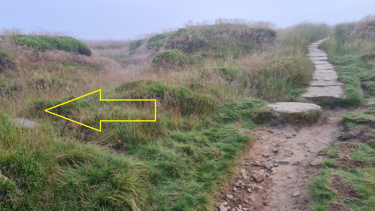
At SK 09848 94244 the paving stones reappear, climbing slightly just ahead of you. Here, i.e. just before the paving stones start again, an intermittent path leaves the PW on the left and goes directly to the crash site. A slab of stone flat on the ground on your left marks the spot where you leave the PW.
It is usually very wet underfoot. This path follows a dike across Alport Low, the dike being marked on OS 1:50000 maps but not on 1:25000 maps. The dike is not that obvious on the ground but can clearly be seen from the southern end of the crash site for the return journey.
The path crosses Crooked Clough at SK 09443 94495 and continues gaining height before turning north to get to the crash site.
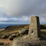
If you want to visit via the trig point at Higher Shelf Stones, you will need to keep heading north west across rough moor (no path) until you come to the edge of the moor and the drop to White Clough, then turn right. It is easy walking up to the trig point.
The path from the PW is fairly clear in good visibility. In low cloud, you might be better off taking the slightly longer route via Hern Clough. In this case, or if you miss the path turning, stick to the intermittently paved sections of the PW, walk past a PW marker stone and as the path emerges from the deep grough you have been in, you will arrive at a cairn where the path appears to fork. It is about half an hour from the lay-by to this point.

Photo above showing the route going to the left of the cairn near Hern Clough. Note the new marker post (see notes below on the sign posts) has gone. However there is a post like this further on at Hern Clough where the route leaves the PW.
Keep left, the path doesn’t actually fork, and another paved section is joined. Higher Shelf Stones is ahead and to the left. The path turns right (north east) briefly but then switches back.
The PW here drops slightly down to the edge of Hern Clough. Keep the stream on your right following the PW as it turns west (left). In a couple of minutes you will arrive at the point where you leave the PW at SK 09708 94773. Here the PW heads north.
Although the “Aircraft Wreck Site” posts have thankfully been removed (see below), there are a few with the white arrow on a black background remaining. There is one at this point now, which is helpful.
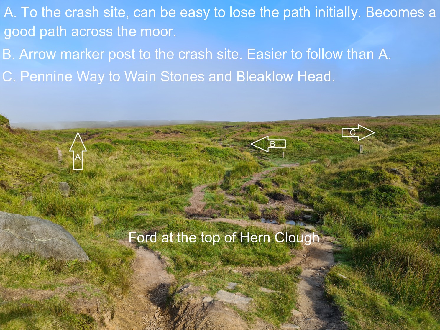
Cross the ford and you have three choices, see photo below.
I would suggest path B which has the signpost mentioned above. You follow another path which immediately turns right (north) and follows another stream, running parallel to the PW for a few minutes in a north westerly direction. At SK 09468 94926 this path leaves the stream and heads west and out across the moor, going directly to the southern end of the crash site.
The photo above was taken from near this marker stone above Hern Clough. It had been toppled but in 2022 has been put back.

At the crash site
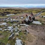
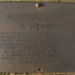
The crash site memorial stone at the north western edge of the site is at SK 09040 94896 which is about 200m to the north east of the trig point on Higher Shelf Stones.
Note the debris is not visible from the trig point, the wreckage being hidden from view by the peat groughs and hags. However, if you need to get your bearings when you are at the site, the trig point is visible from the memorial stone.
The return journey is probably a bit easier – head south east and turn right when you reach the Pennine Way. Going too far to the south will put you in Crooked Clough which will of course mean a climb back out again.
From the southern end of the crash site you can pick up the intermittent path which leads back to the Pennine Way. In clear weather you will see the dike crossing the moor; this is the route back to the PW and the quickest way back to the Snake Pass.
There is also a lovely path which takes you along the south-eastern edge of Crooked Clough and then turns left to briefly follow Doctor’s Gate.

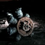
Photo above: if you want to return to the Pennine Way via Hern Clough, the path leaves the crash site near the remains of the tail turret section.
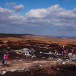
Removing the remains from this air crash site.
There are lots of reasons why people should not remove artefacts from air crash sites, ethical and legal, plus the landowner forbids it too. I often see bits of debris which people have carried and then dumped, presumably because it was too heavy to carry. It also would look a bit obvious, lifting a big piece of debris – clearly stolen from this site – into the boot of a car or back of a van with other people milling about.
A note about the signposting
New signs and posts appeared along the path from the lay-by in 2021. The signs referred to a “waymarked route” to the crash site. The posts have a white arrow on a black background.
There are a number of different route markers along this path; some all yellow in design, some with orange arrows on a green background, others yellow on a white background, pale blue on a navy background etc. Added to that, some of the Pennine Way marker stones had been moved around or toppled over… It could have been confusing.

It did seem an ill-conceived idea to have these signs; there are many recent news reports of Mountain Rescue being called out to people who have gotten into difficulties looking for the wreck site. To have a sign with the words, ‘AIRCRAFT WRECK SITE – Follow waymarked route,’ just a few metres from the lay-by at the top of the Snake Pass (circled in the image below) could have led unprepared visitors deeper into the moors.

However, since a visit in November 2021, all these “Aircraft Wreck Site” signs have been removed which I am sure was a sensible decision. Also I was pleased to see the once toppled marker post above Hern Clough had been put back.
My suggestion for anyone intending to visit the aircrash site is to use map and compass / GPS or go with an experienced guide. The notes provided above are an addition to – not instead of – using map and compass and GPS if you have one.
Visiting other crash sites on Bleaklow
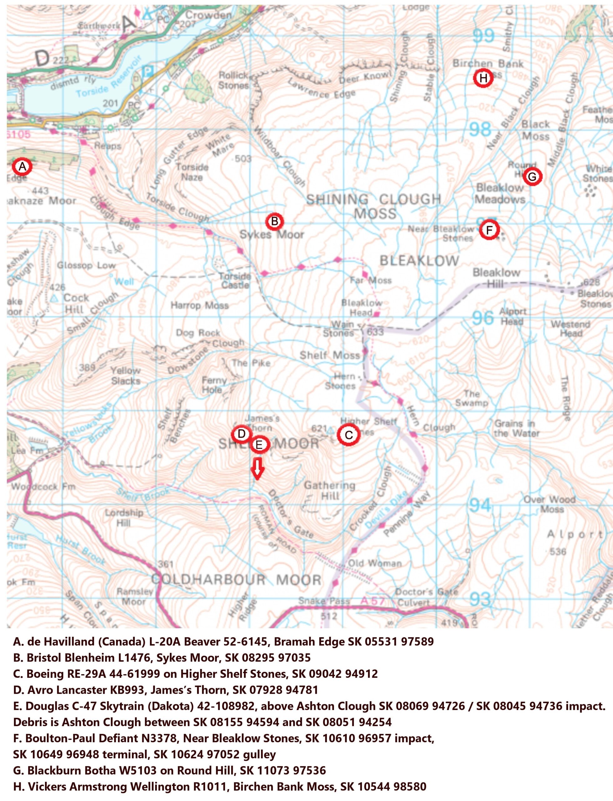
There are at least 8 crash sites on Bleaklow, depending on how you define its boundaries. I have listed them here. It would make a tough challenge walk to visit them all in one day. If I was going to do it, I’d probably park by Torside reservoir and visit the site of de Havilland Beaver 52-6145 at Bramah Edge first, get the steepest climb out of the way. Then Blenheim L1476, on to ‘Over-Exposed!’ and so on. It would require a climb back from the bottom of Ashton Clough if you want to see the wreckage in the clough, then follow the Pennine Way, via Doctor’s Gate, over Bleaklow to the other three sites, then back down to Longdendale. About 16 miles, I reckon. But of course, you can pick and choose which to visit and hopefully these grid references (via Pat Cunningham) will help. All of these air crash sites are detailed on this website.
On 14th November 2014 my son and I visited the crash site of ‘Over Exposed’ on Bleaklow and returned down White Clough and then West along the Doctor’s Gate path. As we approached Doctor’s Gate we were upset to discover that part of the aircraft from the crash site had been abandoned next to a newly erected fence by Shelf Brook, probably after it had been taken from the site by ‘collectors’. It appeared to be part of the nose, or tail, wheel assembly and included the chromed stanchion and steel fittings. It was very heavy and may have been left after the ‘collectors’ became tired of carrying the weight more than a kilometer from the site. It’s a shame that the wreckage can’t be left alone to act as a memorial to those who died in the crash.
Hi Martin, thanks for your comment. The people who remove wreckage – whether to sell on e-bay or for their private collection (i.e. their garden shed) or for use in a project that has as much chance of getting off the ground as the crashed aircraft – show no respect for the men who died at these places or indeed the surviving family members or other visitors. No doubt your analysis is correct; some people got fed up carrying the debris and dumped it. I wonder if it is from the C-47 crash site in Ashton Clough? I agree, these places are now like memorials and should be left alone. It is unlawful to remove debris as well as unethical but clearly that won’t stop the minority.
Well I am surprised that all this metal is left lying around for people to injure themselves on, not sensible people but there are people who will mess around with the wreckage as can be seen , it would be more respectful to the dead to clean up the site and put a proper memorial there instead of twisted metal…
I like it how it is.
So do I Ian, TBF Andrew, you have to make a specific effort to come across it, its hardly strewn across the Pennine way.
i’m sure there are laws against the taking of artefacts from these sites, but who’s going to police them ?
That’s the problem Clive. The only way crash site remains will be visible to at least some people in future is if people stop removing them now. But it will all disappear in time.
Excellent directions and advice. Many thanks.
Thanks Simon
finally got to have a walk up there today a very solam place indeed directions were spot on
Thank you
Only just found out about this after living so close and driving past for the last 30 years ! well worth the visit, don’t underestimate the moors, the weather or the need for boots.
Used it to help bring my nephew’s GCSE work to life.
Take care on the parking in the laybys, I think I counted 4 layers of resurfacing, which is a bit of a step down to park if you are going a bit fast!
I didn’t take the directions, but with a bit of common sense and google on the phone, we were able to get to it first time.
The morons who take wreckage from these sites aree very disrespectful but it s diffcult to see how it can be stopped.
I myself have visted this particular site many, many times over more than 40 years and each time there is less wreckage left. Obviously some parts have decayed to dust but it is obvious that others have been removed. I find that quite distressing.
Went today walked inland from the lay by on the road, walked following all the posts qith arrows on them, right up into the moorland, went in every direction for hours, couldnt find the place no where, we were out there over 3 hours to it and looking around but couldn’t find it 😭😭
Hi Mandy, sorry you never found the crash site. It sounds like you followed the Pennine Way a bit too far.
Did see a cairn with an arrow pointing left, then shortly after that there was a stream on your right? Where the Pennine Way crosses the stream is where the path to the crash site branches off on the left.
Ian
Ok thanku for replying, we have been off work this week, so with it being VJ anniversary we are goin to go back today to see if qe can find it following your directions 🙏🙏 thanku x
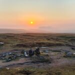
You have probably set off already, but in this photo viewed from the lay-by on Snake Pass, Higher Shelf Stones is the summit on the right.
Hope you have a successful trip!
Ian
Hey…yessss found it..thanku for you directions..the stream that crosses ya path was the big indicator…we went milea past there yesterday…
wowww what an eerie feeling, very somber, a few people looking, just stood quietly thinking, amazing experience, thanku so much for your help x2
Fab! So pleased you found it Mandy, thanks for letting me know. It is frustrating to walk miles and not be able to find a crash site, I know how you must have felt yesterday.
Yes it is a very sombre place, but it’s good that you made the effort (twice!) to visit and pay your respects.
Ian
Would you say the terrain is suitable for a 2 year old? Given the duration he’d be in a carrier some of the way. Thanks.
I’m not sure it’s ideal Helen but others might say it’s fine? Would be a struggle for a 2 year old but if in a carrier, maybe. I honestly can’t advise.
It is fairly easy walking but over uneven and often boggy ground so I’d err on the side of caution and say not, personally, and if you needed help it can be difficult to get a connection up there.
The initial path from the layby on Snake Pass is very easy walking, so you could start out if the weather is clear and dry, and see how it goes? Lots of people stroll out along the path for a short distance then return to their cars.
Ian
Thanks, conditions sound a little unreliable so I think I will err on the side of caution as you suggest and go without the little one. 🙂
My name is Terry David Moore, born Feb. 15, 1946, age 75.
My Father was David Devere Moore, the Radar operator on this flight.
My Mother, Doris Moore, my Brother Tom Moore, and myself, Terry Moore were the only surviving family members.
Also surviving was David Devere’s Mother, Mary L. Moore.
My Brother was born Nov. 3, 1947.
The crash occurred on his 1st Birthday.
There is, however sad, no good day for your Father to be killed.
In 1948 there Was no Radar Altimeter so the Radar operator likely had not much to do on this flight.
All these flyers were likely WW2 VETS who had much experience with very serious, difficult flights.
The flyers were likely thinking this was a ” Milk Run ” flight and did not pay the same attention as perhaps on other more serious flights.
The USAF Crash report states the weather that day was cloudy/foggy, perhaps drizzling rainy, and about 2000 ft. ceiling at best.
It also states there would have been a fairly strong head wind, quartering in.
When it crashed the aircraft was off course by a few miles.
likely due to the head wind.
It was also likely the pilot was not completely accounting for the head wind in his decent.
In his descending just at a good time by clock time, in the fog and low ceiling, the wind may have placed the aircraft at a lesser distance forward then thought.
In order to get below the 2000 ft. ceiling, and off course slightly by the wind, the pilot found 2050 ft. ” Bleaklow Hill ”
David Devere Moore is buried in Arlington National Cemetary in Wash., DC., Section 12, right down hill from the Tomb of the Unknown soldier.
His death took a big toll on our small family and is still felt to this day.
As would be for the other families involved as well.
I would like to travel to visit the crash site but the birthdays may have advanced a bit too far to be realistic.
My Son, David Moore, did visit the crash site.
I could post a picture of David Devere Moore, Circa 1943 if anyone would like.
He looked a bit like the Movie actor Tyrone Power.
Thank you for your reverence to those who died in this accident.
Terry David Moore Email : tmoore77@cox.net
Hello Terry,
Thank you for commenting here and apologies for the delay in replying.
I had intended to visit the site this afternoon and take some new photos but alas, something happened which scuppered my plans for the day. I will get back there soon and will leave a poppy cross with your dad’s name on it in remembrance of him. This is probably the best known and most often visited air crash site in the UK.
Meanwhile it would be lovely to see the photo of your dad. If you can email it to me I will upload it here.
Best wishes,
Ian
Finally got around to visiting for the first time last week during a break in the weather (Just before the current storm).
I was surprised at how busy it was…there were a dozen or so cars parked up when I arrived, someone came to ask me if I was going to the crash site..there were always several people visible on the path both in front and behind me, and when I got back someone else asked me how difficult it was to reach, so I directed them here.
It’s nice to see that by and large (with a few exceptions over the years) the site has been left as it was for the last 75 years despite the high number of visitors.
If anyone is interested there is a complete 8 page write up about
“OVER EXPOSED” IN the
November 2022 edition of
‘Flypast’
It’s worth making the effort to read.
Thanks Brian, I shall get a copy. Years since I bought Flypast
Ian
I visited today. The directions were very helpful. I’m glad I went. Was nice to pay my respects. Good view from the trig point too. Thanks again
Many thanks for the feedback Damian, I’m pleased the info was useful.
Ian.
Thanks for the kind & respectful words on the RB-29 crash site.
I would have loved to come and visit and climb to the crash site.
I still would like that.
I first learned of the crash site in about 1995, VIA letter from an interested person trying to research the crash.
Since then Birthdays have passed, body parts, joints, legs, feet, have become less co-operative for such adventures.
I am Terry David Moore, last living direct relative of David Devere Moore.
He was the Radar operator on Overexposed.
My only Brother, Tom Moore just died on Dec. 7, 2022.
He died from Cancer.
He was 75, I am 76, 77 on Feb 15.
Tom Moore’s last Birthday was Nov.3, 2022.
The crash happened on his 1st Birthday, he was born Nov. 3, 1947.
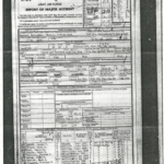
If you care to read the report from the recovery party in full, you may find out how David Devere Moore perished.
You may need to read up on the crew positions in the plane during flight.
After reading the entire recovery report you can figure out how he died.
It will likely not make you pleased that you read it.
Care should be taken before reading as it will be very disturbing reading.
Facts, yes, but not for everyone to read.
David Devere Moore is buried in Wash. D.C, USA.
Arlington National Cemetary, Section 12.
He was 29 when he perished.
He left a wife and 2 Sons.
David Devere Moore was a WW2 veteran who flew during the War from UK during anti submarine duty in B-24 Bombers.
Most if not all the crash victims were WW2 Vets.
Thanks to all for your kindness and solumn remembrance of the guys who perished in the crash.
Terry David Moore
Thank you for your visit Terry, and thank you too for the additional information. I was up at gthe crash site just a couple of weeks ago. It is always a sombre place to be. I visit at least once a year to pay my respects.
I was saddened to read of the death of your brother Tom. There are no words Terry, but I wish you and your family well.
For those who don’t know about your father, please see this page.
Staff Sergeant David Devere Moore
Ian
i’ve known about this crash site for about 30 years or so and finally this weekend my wife and i decided to venture to it. such a tragic accident to of happened and very sad knowing that 13 lives were lost.
the site is a very sombre place… we barely spoke while wondering around the wreckage. just wish people would take there rubbish away and leave the the site alone and not take pieces with them as souvenirs.
Good morning
I’m looking to visit the site today.
Is there a postcode for the lay-by please ?
Hi, may be a bit late now but it is approximately S33 0AB. You’ll see parked cars either side of the road.
Ian
For those who use What3words, the site is located at ///also.scoping.passenger