
Crash site of Hurricane PG472 near Bolton, Lancashire
‹ Return to RAF Crash Sites 1942 – 1945

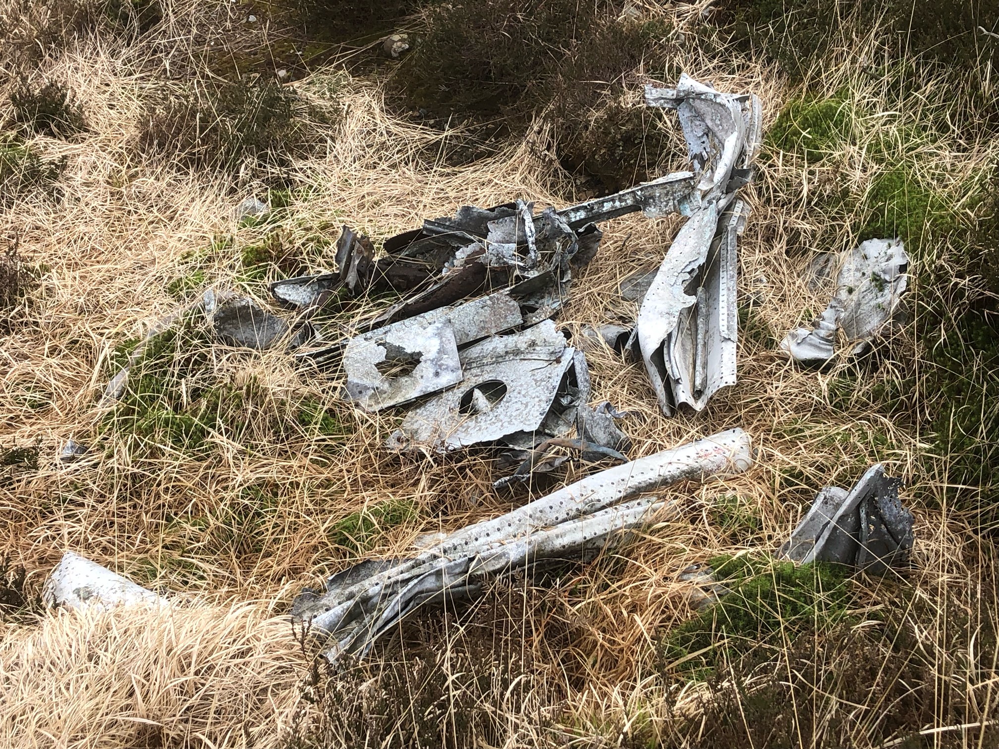
Crash site of Hurricane PG472 near Bolton, Lancashire
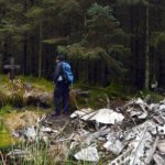
In the distance you can see the Winter Hill transmission tower.
February 2nd, 1945. Two 21 year old Hurricane pilots with orders to undertake flying exercises within the vicinity of their base at RAF Calverley in Cheshire, immediately flew North in formation. 20 minutes later, Flight Sergeant Thomas Stanley Taylor and Warrant Officer Norman Thomas Huckle crashed into each other at about 6,000 feet in cloud and dived to the ground north of Bolton in Lancashire. Both men were killed. Warrant Officer Huckle’s Hurricane came down close by, at Horrocks Fold Farm.
A factory worker later responded to a newspaper appeal for information and said that a colleague of hers had been engaged to one of the pilots; they were going to give the factory girls an unauthorised air display but alas they never arrived.
Grid reference SD 68832 14134
Relatives of Flight Sergeant Taylor please see comment and photo here by Norman Hodgson
Update April 2024
Photos below provided by John Tinsley and used with his kind permission, following his visit to this site in April 2024.
Please see John’s Youtube channel Escapes with B.C for more.


is this recent this shot? definately speaks of a hot summer that’s for sure. perhaps Paul doesn’t recognise the site due the amazing weather! great pov, beautiful colours and nicely captured site. sad ending for these two boys, and their families.
Thanks Ang, this was last summer, a visit to a site with Richard Tierney.
Hi Ian, 11 years and I’m just finding this. I live in St Helens and would really appreciate visiting this site. Whimbury hill doesn’t appear on my google earth. I think I may have a location from the info and pics. Is there any chance of a more precise location? Having returned from Overexposed, I find it very humbling and would love to show my respect for these men everywhere I can. If you could provide any information please know that it is in the strictest confidence.
Many thanks
John
Hi John, apologies for the late reply. I have been ill and not paying much attention to my website. Let me know if you still need the information and I will email you privately (I can see your email address)
Hi Ian,
Yes please, I have literally just got back from winter hill, I went to the impact point of the tragic Manx air disaster to pay my respects. I can’t have been too far from the Hurricane site.
Many thanks
John.
Hi John,
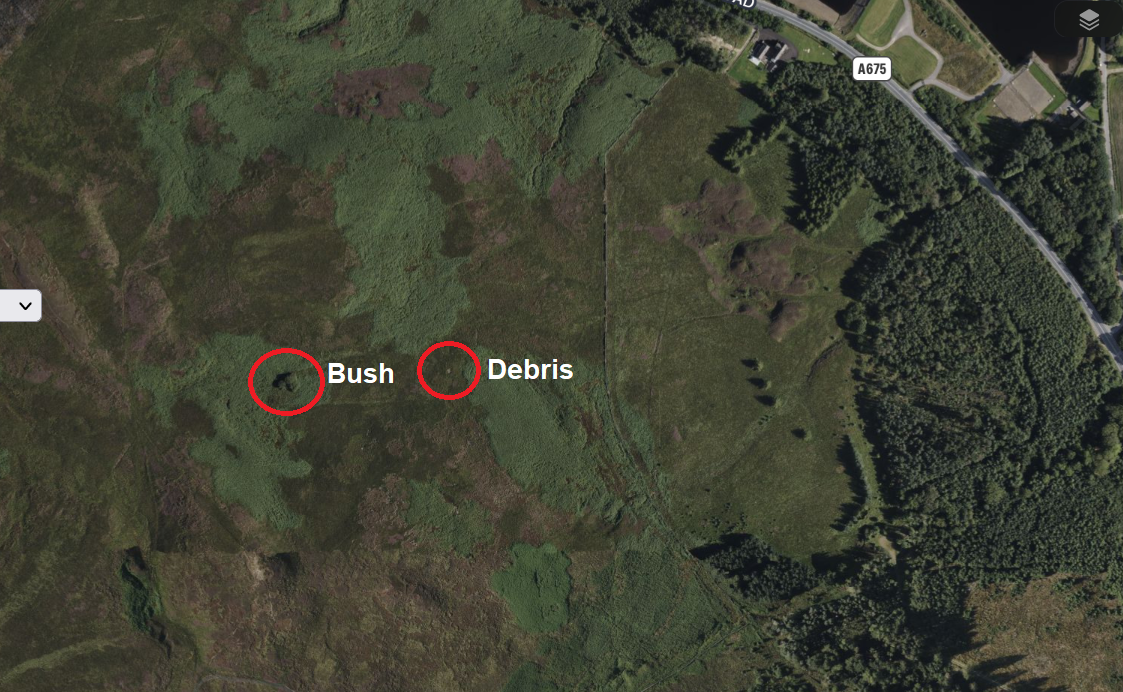
I hope this map helps. I have included the grid reference. The crash site is in open access land, but there are no public footpaths or access points nearby. It’ll probably require some tramping across the moor to get to it, in other words.
In the photo above, you can see when looking from the crash site up to the masts on Winter Hill, there is a bush in the middle distance, just to the left. That bush is about 500 feet from the crash site, so you could keep an eye out for that to help with navigation? The crash site is roughly the same distance from the bush as from the wall.
Ian
Ian, thank you so much. That is my weekend sorted. I really appreciate the info. I hope you feel better soon pal. I’ll be sure to send you the photos.
Many thanks
John
Thanks John, hope you find it. Can email me photos if you wish (email address on the contact page) and I will add them here, with a credit to you of course. I’ve not been to that site in years but you can see it on Google maps so there is still debris there I think.
Hi Ian,
No luck I’m afraid. Was up there for hours. Unfortunately the bush is no more lol. You said it was visible on google maps? Is there any chance you could screen shot it for me? I’m not giving up on this one. After this I think Black Hamelton is next.
Thanks in advance
John.
Hi John
I am sorry you never found the crash site.
The bush is still shown on satellite images though may have disappeared since of course. Or I may have recorded it incorrectly.
Below are three seperate satellite images. If all else fails, we’ll look for it together. Hope you find it. Do you have a GPS device? It’s hard to find it without one, bit of a needle in a haystack job, I’m afraid.
Ian
Hi Ian. Yes that is the exact point I thought it was from a satellite image. I think I got turned around. I tried to be clever and approach from the north. It was much harder going. I’m planning a return trip in the morning. I’m going to take a more direct route. I have a grid ref finder on my phone. Unfortunately I can’t enter coordinates I just have to walk and match up the numbers. I really appreciate your offer of a duo hunt. That is so kind of you! I’ll hit the moors again in the morning. If that fails I may be taking you up on your kind offer.
Many thanks
John
Hi Ian. I have emailed you the pictures. Mission successful!
Thank you for your help pal.
Smashing, thanks John. Have just emailed you and added the photos above. Great that you found the site and thank you again for the photos.
Ian